In this week’s lab, we moved back into exploring with the Wolfpaving data set but this time we added in GCPs, (Ground Control Points). GCPs are designated as spots on the surface of the earth that are observed positions used to geo-reference imagery. Our class needed to go back into the Wolfpaving Data and reprocess it to show the difference between the maps with GCPs and the one from last week (non-GCPs). When it comes to quality, using GCPs can help improve your data if your drone is not RTK equipped. RTK (Real-time kinematic positioning) is a satellite navigation system used to improve the precision of point data obtained from satellite-based positioning systems. This can be anything from the U.S (GPS), GLONASS, Galileo, etc. So, without RTK, Skipping ground control points may generate not a precise finished project, and the regeneration of the data might not have an exact measure and orientation. Many people get confused when discussing GCPs and think that they are in relation to checkpoints produced in Pix4D. When it comes to checkpoints, they are used to estimate the complete exactness of a given model, in this case, the Wolfpaving data. The marks of the checkpoints are used to determine the 3D position as well as any errors when clicking on GCPs. To see how off the first indicated positions were from the GCP’s locations, you are able to see the results in the quality report: figure 1
 |
| Figure 1 (Initial Quality Report) |
Methods
Working with the Wolfpaving Data again this week made it easy to find everything and be able to reprocess it with GCPs. I was able to get the GCP coordinates via a text file, provided in the Class 319 folder. The coordinates were presented in a YXZ format for proper accuracy & location (figure 2). We were able to import the data into Pix4D under the project tab. Making sure that Pix4D knows that you data is in YXZ format is important otherwise your point locations may leave thinking that you did something wrong. I initially didn't take note of this a saw that my point locations were in South Africa and not in the United States midwest. So, I had to manually enter the format and regenerate the location of the points to get the correct positions.
 |
| Figure 2 (GCP Coordinates) |
 |
| Figure 3: GCP and Clicked Location using rayCloud |
Discussion/ Comparison
 |
| Figure 4: Ortho Comparison |
Looking at this week’s lab, you can see in the Orthomosaic with GCPs, the GCPs align with the painted GCPs. This makes the overlap of the projection to the ground a whole lot more accurate and items in the map are more easily defined as seen in (figure 4). Once the data was processed in Pix4D, I moved the data over to ArcGISPro and developed a map with insets to show GCP locations (figure 5). I made the GCP locations a ‘red cross’ to make it easily visible to distinguish their locations. I even zoomed in on the Wolfpaving data to where there is a work trailer to show the detail of the given map processed. Overall this was a fun lab and experiencing the use of GCPs helped me understand the concept of precision when it comes to work-related jobs in this field.
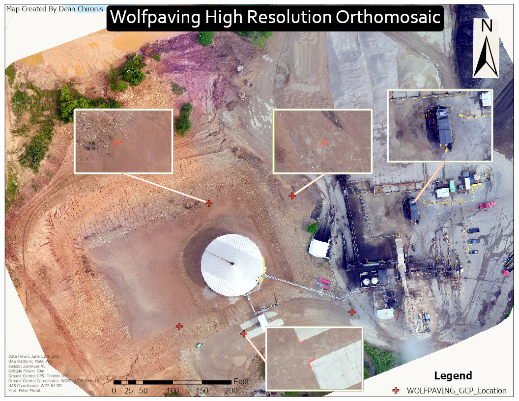 |
| Figure 5: (Final Product GCP Orthomosaic) |
Conclusion
The use of GCPs makes me recognize the accuracy of the data that we are able to process. I also learned about the significance of proper field notes when it comes to data collection. When we enter this industry, we want to make sure that we prepare the best and most accurate results for our client. This shows them our skill set as well as the capability of solving/ viewing a certain problem.